- Introduction
- How to Map
- Mapping Challenge
- Other Resources
In collaboration with:

Share this:
Project NOAH and OpenStreetMap Mapping Initiative
Community-Driven Mapping for Disaster Risk Reduction
 Stand on a sea of rubble. Photo by Mahar Lagmay.
In response to President Aquino's instructions to put in place a responsive program for disaster prevention and mitigation, specifically, for the Philippines' warning agencies to be able to provide a 6 hour lead-time warning to vulnerable communities against impending floods and to use advanced technology to enhance current geo-hazard maps, the Nationwide Operational Assessment of Hazards (Project NOAH) was launched by the Department of Science and Technology to undertake disaster science research and development, advance the use of cutting edge technologies and recommend innovative information services. Through the use of science and technology and in partnership with the academe and other stakeholders, the DOST through Project NOAH is taking a multi-disciplinary approach in developing systems, tools, and other technologies that could be operationalized by the government to help prevent and mitigate disasters.
OpenStreetMap is a free, editable map of the whole world. OpenStreetMap volunteers have been helping many humanitarian organizations in providing comprehensive and updated geographic data for disaster risk reduction and response. For more information about OpenStreetMap's mapping response during Typhoon Yolanda/Haiyan, check out this wiki and video.
You can help Project NOAH and OpenStreetMap Philippines by contributing your time to mapping the Philippines in OpenStreetMap. What you contribute will be used by Project NOAH researchers in developing hazard and impact scenarios to help prevent and mitigate disasters.
How to Map
Editing data in OpenStreetMap
Mapping in OpenStreetMap is as easy as these 3 steps.
- Set up an account and get a log in from OpenStreetMap.
- Learn to map. Watch this video and follow the instructions.
- Start mapping!
No time to edit the map? Use the OpenStreetMap Notes
OpenStreetMap Notes allows you to easily add a marker for errors or missing information in the map data.
- To add a note, click the bottom tool bar button on the right side of the main OSM map.
- Leave a short message on the map if something is missing or obviously wrong.
- An experienced mapper can use these Notes as reference to edit the map.
Mapping Challenge of the Month
Mapping all hospitals
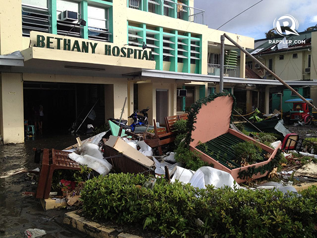 Bethany Hospital in Tacloban City is in need of supplies, particularly anti-tetanus medicine. Photo Credit:
Rupert Ambil/Rappler
Bethany Hospital in Tacloban City is in need of supplies, particularly anti-tetanus medicine. Photo Credit:
Rupert Ambil/Rappler
We need to collect an updated geographic data for hospitals. For Project NOAH's research, we need to assess if hospitals are safe from hazards. Furthermore, hospitals are critical infrastructure in times of disasters. During disaster relief and response, we need to know the location of hospitals in order to efficiently direct aid and other medical assistance.
To map hospitals in OpenStreetMap:
- Browse the map to check if the hospitals in your neighborhood were already in OpenStreetMap. You can also check this list of hospitals from the Department of Health database.
- Add as much detail within the hospital such as buildings, roads and other structures.
- When saving your edits, add this comment to your changeset
"#noah_hospitals".
Current data and contributions
Location of Hospitals in OSM
Last 7 days of edits
Latest edits with the changeset tag"#noah_hospitals" from http://resultmaps.neis-one.org/osm-changesets.
Some numbers
| Number of Health Facilities in the DOH Database | 20,059 |
| Number of Hospitals mapped in OSM | points: 768, lines: 1, polygons: 815 |
| Number of Contributors | 31 |
| Date | May-27-2014 |
Other Resources
- Project NOAH's mission is to undertake disaster science research and development, advance the use of cutting edge technologies and recommend innovative information services in government's disaster prevention and mitigation efforts.
- OpenStreetMap is a project to create and distribute free geographic data for the world. It is being built by volunteer contributors.
- Learn to contribute to OpenStreetMap at http://learnosm.org and http://mapgive.state.gov
- Talk to the OpenStreetMap Philippines community (OSM-PH) by visiting http://wiki.openstreetmap.org/wiki/Philippines, joining the mailing-list and visiting https://www.facebook.com/OSMPH.
- Comments and correction on this page, go to: https://github.com/maning/noah_osm_mapping.